Max Patch Mountain with view towards the southeast
| WEATHER | | | CALENDARS | | | ADVENTURES | | | TRAVELS | | | MUSIC | | | COUPONS | | | BOOKS | |||||||
|
Pisgah
National Forest
Appalachian/French Broad Ranger District
|
|||||||||||||||||||
View a map of the area
Highlights;
Harmon Den Area
This area offers good opportunities for dispersed camping, fishing, mountain
biking and horse-back riding. A day-use area for horse trailer parking is located
on Cold Springs Road (FS #148). There are several horse trails in the area.
Many miles of closed roads may be used for hiking, biking or horse back riding.
Several access trails lead to the Appalachian Trail. There are many trails that
can be connected to make hiking loops.
Murray Branch Recreation
Area
This area is 6 miles downriver from Hot Springs, NC. This area offers picnicking,
fishing, canoe and kayak access to the French Broad River. Facilities at the
area include picnic tables, grills, restrooms, water and two picnic shelters
for large groups. An easy 1-mile loop trail is adjacent to the area. Follow
it for a bird's eye view of the French Broad River and the surrounding valley.
Silvermine Campground
Group Camping - accomodates up to 75 people. Reservations required: Call 828-622-3202
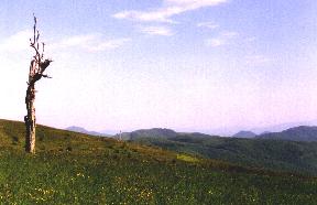
Max Patch Mountain with view towards the southeast
Max Patch Mountain
This 350 acre tract of open land on a high knob overlooks the Great Smoky Mountains
and the Black Mountain Range. Purchased to relocate the Appalachian Trail off
the highway and onto national forest land, this area has an elevation of 4,500
feet. The area is closed to motor vehicles, although there is road access and
parking near the summit, which requires about 1/4 mile uphill walk. Visitors
are encouraged to travel the area by foot and enjoy the fresh mountain air and
clear views of open country. Many visitors come to Max Patch to camp, fly kites
and walk the Appalachian Trail. Max Patch Mountain's 360 degree views offer
exceptional sky watching as well when the weather is clear.
Rocky Bluff Recreation
Area
This developed camping and picnicking area provides a nature trail to Spring
Creek. The 1-mile trail goes through different types of vegetation and forest
cover. The area also contains a 3/4-mile hiking trail along the stream. Rocky
Bluff is a fee area and provides drinking water, campsites and restrooms, but
no showers.
APPALACIAN/FRENCH
BROAD RANGER DISTRICT:
DISTRICT RANGER-USDA FOREST SERVICE
PO BOX 128
HOT SPRINGS, NC 28743
PHONE: 828-622-3202
© 1995-2002 NCNatural, Last updated