WEATHER | CALENDARS | ADVENTURES | TRAVELS | MUSIC | COUPONS | BOOKS
NCNatural's Linville Gorge
Linville Gorge
Mountain Biking
   
|
ABOUT US | CONTACT

The Linville Gorge Area offers some of the most strenuous mountain biking anywhere in the east, with a variety of routes ranging from 8.2 miles to 49 miles and some mighty incredible scenery along the way.

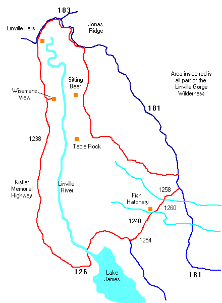
Trail - Route Map
Linville Gorge Loop

Distance: 49.2 miles
Difficulty: Strenuous
Riding Surface: Dirt Road, Paved Road
Route: All the way round the gorge using the Kitsler Highway and Hwys 126 and 183, and several Forest Service Rds. This is a very hard ride and should not be attempted by anyone but really IN SHAPE folks !

Wiseman's View Ride

Distance: 8.2 miles
Difficulty: Moderate
Riding Surface: Dirt Road
Route: Starting at Linville Falls parking area - the route travels down and back the Kistler Memorial Highway ( it's NOT A HIGHWAY, it is a rather rough dirt road)

Table Rock Loop

Distance: 26.2 miles
Difficulty: Strenuous
Riding Surface: Dirt Road, Paved Road
Route: Start at Intersection of F.R. 210 and F.R. 210-B. Traveling south towards Hwy 181. Follow 181 north to Gingercake Acres Rd. (also F.R. 210) Return to starting point.

Featured Books
Bicycling the Blue Ridge : A Guide to the Skyline Drive and the Blue Ridge Parkway
~ Usually ships in 6 days

Elizabeth Skinner, Charlie Skinner (Contributor) / Paperback / Published Feb. 2000
Our Price: $12.95
Blue Horizons : Faces and Places from a Bicycle Journey Along the Blue Ridge Parkway
~Usually ships in 2-3 days

Jerry Bledsoe / Paperback / Published 1993
Our Price: $11.95
Mountain Biking the Appalachians - Northwest North Carolina / Southwest Virginia
~ usually ships in 2-3 days
Lori Finley, Thomas Horsch
Our Price: $8.76

© 1995-2002 NCNatural, Last updated