The Challenge
of Tsali
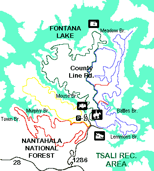 Probably
the most popular features of Tsali Recreation Area are the 39 miles of trails
suited for mountain bikers and horse-back riders, as well as hikers. The 4-loop
system offers a variety of landscapes. You can climb 1-foot wide rugged paths
or travel flat, well-beaten roads. The four trails--Right, Left, Mouse Branch,
and Thompson Loops--meander through mixed pine and hardwoods on a peninsula
stretching into Fontana Lake.
Probably
the most popular features of Tsali Recreation Area are the 39 miles of trails
suited for mountain bikers and horse-back riders, as well as hikers. The 4-loop
system offers a variety of landscapes. You can climb 1-foot wide rugged paths
or travel flat, well-beaten roads. The four trails--Right, Left, Mouse Branch,
and Thompson Loops--meander through mixed pine and hardwoods on a peninsula
stretching into Fontana Lake.
Hikers may travel the trails any
day, but mounatin bikers and equestrians, the primary users, are kept separated
by alternating use of trails. A schedule is posted at all trailheads. There
is a fee for mountain bikers. Check in at the Cheoah District Ranger Station.
Here's a preview of what you'll
discover on the Tsali trails;
- Right Loop
Length: 11 miles
Highlights: Single track, views of Lake Fontana, creek crossings, shorter
4- and 8- mile loops possible.
- Left Loop
Length: 11.9 miles
Highlights: Longest Tsali trail, single track, creek crossings, views of the
Smokies and Lake Fontana at the overlook.
- Mouse Branch
Length: 6.5 miles Highlights: Single track and old logging roads, potential
views of wild turkey, deer, and grouse in forest wildlife openings, old home
sites.
- Thompson Loop
Length: 7.7 miles Highlights: Single track, potential views of wildlife, overlooks,
stream crossings, old logging roads, old home sites.
Some History
The Tsali Recreation Area is named for a Cherokee man who hid in this area in
1838. The US Government had ordered the Cherokees to move to Oklahoma--a tragic
removal that's known as "The Trail of Tears". Exasperated by the brutality
to his family, Tsali and others managed to escape to these mountains.
Tsali was coaxed to surrender by
a promise to allow the others to remain in the area. Tsali voluntarily came
forward as a sacrifice for his people. As a result, he, his brother, and two
older sons were shot and killed.
Today the Eastern Band of the Cherokee
live on ancestral Cherokee land about 12 air-miles east of the Tsali Recreation
Area.
Forest Management
National Forests are managed for many uses, including outstanding recreation,
wildlife habitat, wood products, and clean water. Watch for signs of forest
management.
The pine forest here is threatened
by the southern pine beetles. To control the beetles, infested trees are cut
and removed. A ring of healthy pines around the infestation are also removed
to create a buffer.
You will discover many grassy openings
created for wildlife on the Tsali peninsula. These small plots were cleared
and seeded with orchard grass and clover. Some animals benefiting from these
openings are wild turkeys, white-tailed deer, ruffed grouse, rabbits, songbirds,
and butterflies.
Tsali Campground
Showers, flush toilets, and 41 campsites are offered at this campground. Bikers
can head straight from the tent door to the trails.
Dispersed Camping
You may camp anywhere on forest service land, except in designated wildlife
fields and in trail parking lots. Along entrance road (FR 1286), camp only at
designated sites. Please leave your campsite clean by packing out all trash
when you go. campfires are permitted, but a stove is recommended. Live trees
may not be cut; use dead or downed wood. Be sure your fire is dead out when
you leave. Bury all human waste and toilet paper.
Accessible Facilities
Restrooms located in the lower loop and nearby camping units are accessible.
Parking Facilities
The trailhead parking lot is for day trail use. Facilities include a restroom,
bike-washing station, picnic tables.
Boating & Fishing
No fee is charged to use the boat launch and ample parking is available. lake
fishing is permitted year-round. For information about fishing licenses, contact
the North Carolina Wildlife Resources Commission at 919 662-4381.
©
1995-2002 NCNatural, Last updated