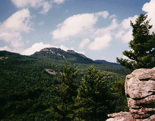
The Grand Canyon of North Carolina
|
NCNatural's
Guide to Linville Gorge
|
 |
| WEATHER | | | CALENDARS | | | ADVENTURES | | | TRAVELS | | | MUSIC | | | COUPONS | | | BOOKS | |||||||
|
Pisgah
National Forest
Grandfather Ranger District - Linville Gorge
|
|||||||||||||||||||
The Grand Canyon of North Carolina
|
NCNatural's
Guide to Linville Gorge
|
|
Linville Gorge was first designated a wild area in 1951 by the Chief of the Forest Service. With the signing of the Wilderness Act of 1964, the area became one of the original components of the National Wilderness System. The original 7,575 acres was increased to the present 12,002 acres by the 1984 North Carolina Wilderness Act.
The wilderness of the Linville Gorge is rich in both plant and animal life. There are five species of rare plants, several varieties of rhododendron, and virgin forests in the deep coves. The rugged terrain has always made development difficult, and the wilderness designation now prevents development in the gorge. Sand mrtyle, red chokeberry, azalea, turkey beard, bristly locust, yellow root, silverbell, orchids, ninebark, and wild indigo are among the many plant species. Animal species include deer, bear, squirrel, raccoon, grouse, turkey, vultures, owls, hawks, as well as brown and rainbow trout. Hikers should also be wary of copperheads and timber rattlers. Hunting and fishing are allowed but permits are required. Camping is permitted in the gorge but permits are required from May 1 through October 31. It is always a good idea to check in with the rangers and let them know you are going into the gorge. The gorge is a rugged and wild place and visitors should treat the wilderness with respect. We highly recommend a stop at the Linville Falls Visitor Center, open April 15 - November 1 9AM-5PM. The center is well stocked with maps, and the rangers are a great source of "inside" information about the gorge. They also give away pepermint treats and will gladly treat you to some great tales about the gorge and the other nearby recreation areas like Wilson's Creek.
DIRECTIONS
Access to Eastern Section of Gorge
From Marion, take U.S. 221 north
to the Intersection of N.C. 183 at Linville Falls. Turn right on 183 and continue
to N.C. 181. Turn right (south) on N.C. 181 and go 3 miles to F.S. Road 210
(Gingercake Road). rurn right onto F.S. Road 210. At the first fork, turn left
and continue through the Gingercake Acres housing development.
The first parking area is for the Devils Hole Trail - approximately 2 miles
from Gingercake Acres.
The second parking area is for Hawksbill (parking area on left and trail on
right) - 1 mile from Devils Hole.
The third parking area is for Spence Ridge Trail and North Table Rock Trail
- 1 mile from Hawksbill.
Continue 1 mile to the first intersection and turn right (you will pass the
Outward Bound School sign). Stay on this road, bearing to the right, through
several switchbacks and you will arrive at Table Rock Picnic Area.
Access to Western Section of Gorge
From Marion, take Highway 221 north until it intersects with N.C. 183. Turn right on N.C. 183 and continue 1 mile to Old NC 105, Kistler Memorial Highway. Trailheads and parking lots, accessing the western section of the Gorge, lead off of Kistler Memorial Highway.
Kistler Memorial Highway via N.C. 126 can be reached from Marion by travelling down U.S. 70 east to Nebo. At Nebo, take N.C. 126 across Lake James and continue 8 miles until turning left on Old NC 105, Kistler Memorial Highway.
Kistler Highway is a gravel surface road and very rough in places.
It is not recommended for 2-wheel drive vehicles.
© 1995-2002 NCNatural, Last updated