| WEATHER | | | CALENDARS | | | ADVENTURES | | | TRAVELS | | | MUSIC | | | COUPONS | | | BOOKS | |||||||
|
Pisgah
National Forest
Appalachian/Toecane and Grandfather Ranger Districts
|
|||||||||||||||||||

| SITE NO. and NAME | FACILITIES | COMMENTS |
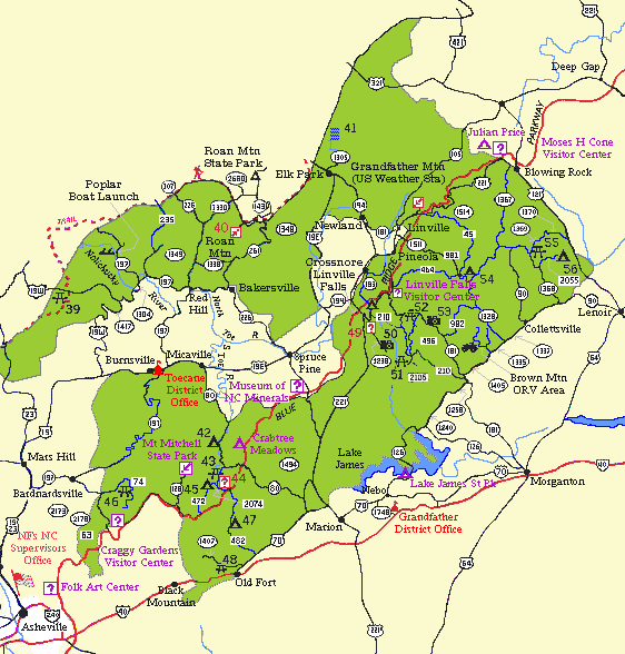
| 39 Spivey | Elevation 3300'. Access to Appalachian Trail. | |
| 40 Roan Mtn. | Click for Official NFS Roan Mountain brochure (PDF format) |
Roads closed in winter, Reknowned Rhododendron bloom in June. Grassy balds. Access to Appalachian Trail. From BAKERSVILLE, take NC 261-N for 13 miles. |
| 41 Elk Falls |
Open all year. Short trail leads to a picturesque 50-foot waterfall where you can picnic and fish. From ELK PARK on NC 194,take FR 190 for about 6 miles. |
|
| 42 Carolina Hemlock | Click for Official NFS Camping Info (PDF format) |
4/14-11/1. Picnic shelter by reservation (877-457-4023). On the South Toe River. Popular swimming hole for tubers. Fee area. From BURNSVILLE, take U.S.19-E for 5 miles, turn right on NC 80 for 9 miles. |
| 43 Lost Cove | On South Toe River | |
| 44 Neals Creek Info | Information, maps | |
| 45 Black Mountain | Click for Official NFS Camping Info (PDF format) |
4/14-11/1.
On South Toe River, Guided activities in season. From BURNSVILLE, take U.S.19-E for 5 miles, turn right on NC 80 for 12 miles, turn right on FR 472 for 3 miles. |
| 46 Corner Rock | On Corner Rock Creek | |
| 47 Curtis Creek | Click for Official NFS Camping Info (PDF format) |
4/1-12/31. Tents only. From OLD FORT,take U.S.70-E for 1.7 miles, turn left on FR 482. |
| 48 Old Fort | Picnic shelter | |
| 49 Linville Gorge Info |
The Information Cabin has information about the Linville Gorge and theGrandfather Ranger District, as well as maps and other information. The cabin is located at the top, on the west side of the Gorge, ¼ mile from Hwy183 onto the gravel Highway 105, also know as the Kistler Memorial Highway. There is a campground near Linville Falls that is run by the National Park Service/Blue Ridge Parkway at Mile Post 316.3 just off the Blue Ridge Parkway. |
|
| 50 Wiseman's View |
Open all year. Spectacular view of Linville Gorge from the west side. Drive slowly on rough gravel road. From town of LINVILLE FALLS,turn right on NC 183 for 1 mile to SR 1238,Kistler Memorial Highway (gravel). |
|
| 51 Table Rock |
4/1-12/31. Views of Linville Gorge from east side of the Gorge. Short trails travel the rim of Linville Gorge to the summit of Table Rock and to the Chimneys. From MORGANTON, take NC 181-N.Turn left at sign onto Gingercake Acres Road (SR 1264), which becomes FR 210 (gravel). Turn right on FR 99. |
|
| 52 Barkhouse | In mountains, off NC 181 | |
| 53 Brown Mountain | Scenic Overlook | |
| 54 Mortimer (Wilson Creek Area) | Click for Official NFS Camping Info (PDF format) |
Campground fee season 4/1-10/31. In winter no water or fee. From LENOIR, take NC 90-W to Collettsville. Turn right on SR 1337. Turn right on SR 1328 (turns to gravel) and go 8.5 miles. At NC 90, turn left. |
| 55 Mulberry | On Mulberry Creek | |
| 56 Boone Fork | Click for Official NFS Camping Info (PDF format) |
4/1-12/31. On Boone Fork. Open 4/1-12/31. Regular and Group campsites. Phone 828-652-2144 for reservations. From LENOIR, take NC 90-W for 7 miles. Turn right on SR 1368 for 3 miles, turn right on FR 2055. |

© 1995-2002 NCNatural, Last updated