|
"We
had better design and build thoughtfully, sensitively, creatively,
as we usher men and women into the presence of the natural gods..."
(Stanley William Abbott, architect of the BRP)
|
|
| The
Blue Ridge Parkway truly brings us into the presence of the natural
gods in a way that is increasingly rare. Travel on the Parkway forces
us to slow down and examine a sublime nature, allowing us to drop our
day-to-day cares and experience the glory around us that can appear
as an unspoiled pastoral nature where cows munch bucolically near the
road or as a ferocious assault from a sudden thunderstorm on a high
wind-swept peak when the world disappears completely from view.
Don't even think
about getting on the Parkway if you're in a hurry. Although it's stated
purpose was to provide a link between Shenandoah National Park in
Virginia and the Great Smoky Mountains National Park in NC/TN, this
is not one of those routes where the shortest distance between two
points is a straight line. Sure, it looks like the shortest route
on the map, but when you factor in the ups and downs and around and
arounds, it gets considerably longer. You'll also find yourself stopping
a lot along the way - even if you didn't think you would. It has been
said that you can't plan spontaneity, but you can leave room for it
to happen. The planners of the Parkway definitely left room for spontaneity
and this is a tourist road not a thoroughfare.
But I digress.
You probably want a few facts.
The Blue Ridge
Parkway is 469 miles long - 217 miles in Virginia, including the Skyline
Drive, and 252 miles in North Carolina. It was conceived during the
Great Depression -though the idea had some germination earlier - as
a scenic tourist link between the two National Parks, previously mentioned.
It was implemented out of a need to put people to work in 1935 during
the Depression and the Civilian Conservation Corp (CCC) provided the
labor.
|
The Blue Ridge Parkway history is full of colorful
characters (though all the old pictures are black and white) and hard
working, determined, supporters. The road was not easily built, nor
was the route easily determined.
|
|
Brinegar
Cabin
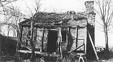
(then)
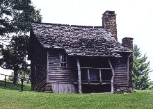
(now)
|
The route through
Virginia was fairly easily established, but a rather bitter rivalry
developed between North Carolina and Tennessee for the rest of the
route, as both states recognized the economic benefits that would
arise in the near and far term. The man responsible for finally determining
the route was Interior Secretary Harold Ickes, who chose a North Carolina
route because there were already two National Forests (Pisgah and
Nantahala) in NC that could be used as a corridor for the Parkway,
because North Carolina was regarded as more scenic and because Tennessee
had already benefited from New Deal projects like the TVA.
Now, if you were
to think about planning a road today, you would probably call an engineer
first. That's not what happened with the Parkway - they called a Landscape
Architect. There were actually quite a few architects and engineers
involved, but the lead architect for most of the project was the young
Stanley Abbott, a Cornell University graduate. Abbott was influenced
by the likes of Frederick Law Olmstead, designer of Central Park in
New York and the surroundings of the Biltmore House in Asheville,
NC. He wanted to create a park-like environment that would blend in
with the natural surroundings and showcase not only panoramic views
of the mountains, but also agricultural settings, streams and forests,
and as it turned out, local folkways.
|
|
Planning and
landscape design for the Parkway began Dec. 26, 1933 and construction
began in Sept. 1935. The Civilian Conservation Corp began work on
several sections of the Parkway simultaneously, with sections being
given priority where employment needs were greatest. Contractors were
mandated to hire local people whenever possible. Four CCC camps were
established at various points along the route to perform the work.
The CCC camps were managed in military style with workers being housed
in barracks, marched in formation and taking turns with kitchen duties.
Almost all of the work on the Parkway, including the rigorous chore
of tunnel digging, was done by hand and with very little machinery.
Work continued
steadily until the start of WW II by which time approximately 2/3
of the Parkway was complete. In 1942, the CCC was closed out and work
on the remaining sections of the Parkway was sporadic. The work was
not completely finished until 1987 when the Linn Cove Viaduct was
completed.
Construction
of hard structures along the route did utilize modern materials like
concrete for bridges, tunnels, dams, and various buildings. Stonemasons
later finished the work with facings of local stone to blend the structures
into their surroundings and give the illusion that the work was done
in a more primitive fashion. The Linn Cove Viaduct section of the
Parkway has been called the "most complicated segmental bridge ever
built". The Viaduct was designed by computer and probably could not
have been done earlier in the project as it required technology to
be developed for its' design. It is an elaborate double-S curve elevated
bridge that skirts the side of Grandfather Mountain at MP 304. The
purpose of elevating the roadway rather than blasting it into the
side of the mountain was to limit the impact on ecologically sensitive
Grandfather Mountain, which is designated by UNESCO as an International
Biosphere Reserve.
|
Tunnel Construction
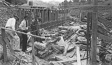
The stone
masons of the Parkway were some of the most talented in the world.
The quality of their work is admired by millions of visitors each
year.
|
Make
no mistake about it - the Blue Ridge Parkway is a masterpiece of design.
While the Parkway today lives up to the ideal of providing a pastoral
route through an apparently pristine environment, it is actually more
of a museum piece showcasing a simpler time that never really existed
in quite that way. Very little of the route was actually pristine nature.
When construction began, much of the landscape had been devastated by
clear-cut logging operations, streams were fouled and commercialization
was already taking over the few scenic areas. Most of the original pioneer
cabins in the area had crumbled into decay or been replaced by more
modern structures, so in several cases cabins from other locations were
moved to the Parkway. Some of the farms along the Parkway were encouraged
to remain and work with the Park Service to preserve the proper atmosphere
by, for instance, maintaining traditional split rail fencing and keeping
heavy farm equipment out of sight. It is still a work in progress. Today
supporters of the Parkway fight to limit development along the route
to preserve vistas as well as being conscious of environmental issues
like smog and acid rain that affect the health of the ecosystems.
|
