
& CAMPING
Blue Ridge Parkway Travel Guide
NC Mile by Mile Travelogue
NC Mile by Mile Travelogue
|
|
|
ABOUT US | | | CONTACT |
| HISTORY | | | HIKING & CAMPING |
| | TRAVELOGUE | | | DESTINATIONS | | | PHOTOS | | | LINKS | |||||||
|
Blue Ridge Parkway Travel Guide
NC Mile by Mile Travelogue
|
|||||||||||||||||
Points of Interest
Major points
of interest along the parkway are listed by milepost from the northern end in
Virginia to the southern end in North Carolina. Here are informational notes
pertaining to the North Carolina, indexed by section.
|
|
|
|
|
|
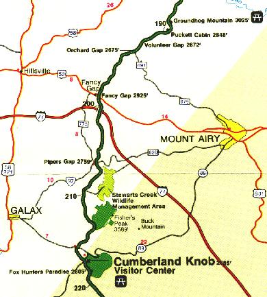
| Mile Post | |
| 190.6 | Va. 608 |
| 191.4 | Va.608 |
| 191.9 | Bluemont Presbyterian Church and Cemetery at private road crossing |
| 192.3 | Va. C-648, left to Mt. Airy; left on Va. C-771 to Wilus Gap |
| 193.2 | Volunteer Gap, elev. 2706 |
| 193.7 | Orchard Gap, elev. 2675. Va. 691, right to Hillsville; left to Mt. Airy |
| 194.7 | Va. 608 |
| 195.5 | Wards Gap, elev. 2750. Va.608; no access |
| 196.45 | Va. 682 |
| 198.4 | Va. 685, left to Va. C-608 |
| 199.0 | Va. 608 |
| 199.1 | Turnoff connects with U.S. 52 |
| 199.4 | Fancy Gap, elev. 2925. U.S.52, left 14 mi. south to Mt. Airy. 1.5 miles north to I-77. |
| 199.9 | Va. C-778 |
| 202.25 | Va.608 |
| 202.8 | Granite Quarry parking overlook, elev. 3015. S. |
| 203.9 | Piedmont overlook |
| 204.85 | Va. 700 |
| 205.75 | Va. 608 |
| 206.1 | Piper Gap, elev. 2759. Va. 620; no access |
| 206.35 | Va. 608, right to Va. 620 and 97 |
| 206.9 | Mt. Carroll Methodist Church and Cemetery |
| 207.75 | Va. 608 |
| 208.25 | Blue Ridge Church and Cemetery; access to Va.C-608 |
| 209.35 | Va. 715, right to Galax |
| 209.85 | Va.716 |
| 209.9 | Hank's Branch |
| 211.1 | Va.612 |
| 212.2 | Hank's Branch |
| 213.1 | E. Fork Chestnut Creek |
| 213.3 | Va. C-612 |
| 215.15 | W. Fork Chestnut Creek |
| 215.3 | Va.799 |
| 215.7 | W. Fork Chestnut Creek |
| 215.85 | Va. 89, right 7 mi. to Galax; left 22 mi. to Mt. Airy |
| 216.0 | W. Fork Chestnut Creek |
| 216.25 | W. Fork Chestnut Creek |
| 216.9 | State Line, Virginia and North Carolina |
| 217.3 | Road connects with N.C.18; right 15 mi. to Sparta; left 22 mi. to Mt. Airy |
| 217.5 | |
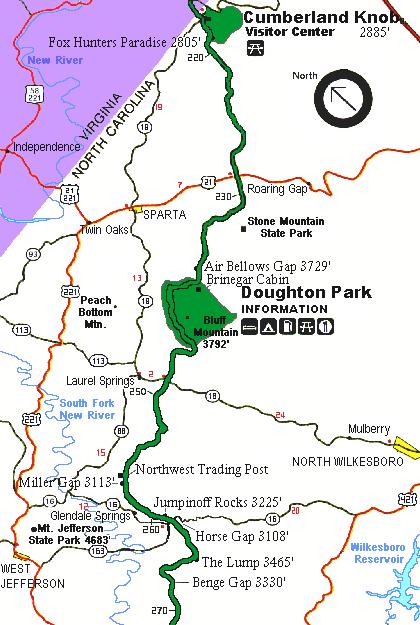
| Cumberland Knob, at 2,885' feet, is a delightful spot to walk through fields and woodlands. Cumberland Knob Trail and Bully Creek Trail. Visitor Center, parking, picnic area, 25 sites, comfort stations, shelter, cemetery. Elev. at Parkway 2740'. | |
| 218.6 | |
| Fox Hunters Paradise, a 10-minute walk, is where hunters could listen to their hounds baying in the valley below. Fox Hunters Paradise parking overlook, elev. 2805. Trail to High Piney Spur.S. |
| Mile Post | |
| 220.4 | Secondary road, N.C. 1460 |
| 221.8 | Saddle Mountain Church, elev. 2755. Secondary road crossing |
| 225.2 | Hare Mill Pond, elev. 2590. Secondary road crossing |
| 226.2 | Secondary road crossing |
| 227.6 | Secondary road crossing |
| 229.2 | Public road crossing |
| 229.6 | U.S. 21, elev. 2700. Right 7 mi. to Sparta; left 25 mi. to Elkin |
| 230.1 | Little Glade Mill Pond parking overlook, elev. 2709. E. Nice pond near a scenic turbine mill. |
| 230.9 | Public road crossing, left to Cherry Lane, to Sparta |
| 231.5 | Public road crossing |
| 231.8 | Public road access |
| 232.5 | Stone Mountain parking overlook. S. |
| 233.7 | Parking widening, elev.3200 |
| 234.0 | Public road access |
| 234.1 | Bullhead Gap, elev. 3193;public road crossing |
| 235.0 | Mahogany Rock parking overlook, elev. 3436 |
| 235.7 | Devil's Garden parking overlook, elev. 3428'. |
| 236.9 | Air Bellows Gap parking overlook, elev. 3744'. |
| 237.15 | Air Bellows Gap, elev. 3729'. Overpass; public road access |
| 238.5 to 244.7 | Doughton Park was named for Congressman Robert L. Doughton, a staunch supporter and neighbor of the parkway. One of the best locations to see deer. |
| 238.5 | |
| Brinegar Cabin was built by Martin Brinegar about 1880 and lived in until the 1930s when the homestead was purchased for the parkway from his widow. The original cabin stands here today. Brinegar Cabin parking overlook, elev. 3508.5. Enter Doughton Park; Brinegar Cabin, weaving exhibits, and gift shop. Cedar Ridge Trail and Bluff Mountain Trail. | |
| 239.3 | |
| Doughton Park Campground. Camping area, 96 campsites, 3 comfort stafions,campfire circle. There are also back-country camp sites available. | |
| 239.4 | |
| Doughton Park RV Camp. Trailer area, 28 trailer sites, 1 comfort station | |
| 239.9 | Low Notch, elev. 3482 |
| 241.1 | |
| Doughton Park concessions and Bluffs Lodge. Right to coffee shop, service station; left to lodge (75 cap.), picnic area, 56 sites. S. Fodder Stack Trail and Bluff Ridge Trail. Wildcat Rocks is where the Caudill family had their homestead. | |
| 242.4 | Alligator Back parking overlook, elev. 3388 |
| 243.4 | Bluffs View parking overlook, elev. 3334 |
| 243.7 | |
| Basin Creek Trail. | |
| 243.8 | Grassy Gap, elev. 3218 |
| 243.95 | |
| Grassy Gap Fire Road | |
| 244.5 | Cemetery |
| 244.7 | |
| Basin Cove parking overlook, elev. 3312. Flat Rock Ridge Trail. | |
| 246.1 | Public road access right to N.C. 18 |
| 246.92 | Public road crossing |
| 247.26 | Public road crossing (unimproved) |
| 248.1 | N.C. 18, right 2 mi. to 2 motels, restaurant, gasoline, Laurel Springs; left 24 mi. to N. Wilkesboro |
| 249.3 | Public road crossing |
| 250.0 | Public road |
| 250.8 | Peak Creek. Public road crossing, right to Upper Mountain experiment station |
| 251.5 | Alder Gap, elev. 3047. Public road access right |
| 252.4 | Public road crossing |
| 252.8 | Sheets Gap parking overlook, elev. 3342. Public road exit on left |
| 254.1 | Rattlesnake Mountain and public road crossing |
| 255.1 | Public road crossing |
| 256.5 | Public road crossing |
| 256.9 | |
| Cherry Hill coffee shop, gift shop, service station | |
| 257.7 | Public road crossing |
| 258.6 | Public road crossing (old N.C. 16), Glendale Springs on right. Northwest Trading Post, gift shop. Northwest Trading Post is sponsored by the Northwest Development Association to keep alive the old crafts within North Carolina's 11 northwestern counties. Homebaked goodies and lots of crafts. Open April 15 to Oct. 31. |
| 259.25 | Public road crossing. Cemetery on left |
| 259.85 | Public road crossing |
| 260.3 | Jumpin-Off Rocks parking area, elev. 3165. |
| 260.6 | |
| Jumpinoff Rocks, at the end of a short woodland trail, offers a beautiful vista. | |
| 261.2 | Horse Gap, elev. 3108. N.C.16, right 12 mi. to W. Jefferson; left 22 mi. to N. Wilkesboro |
| 262.25 | Daniel Gap, elev. 3167 |
| 263.15 | Joint crossing |
| 263.7 | Gilliam Gap, elev. 3238. Private crossing |
| 264.4 | |
| The Lump provides sweeping views of the forested foothills. | |
| 264.45 | The Lump parking overlook, elev. 3465 |
| 265.15 | Calloway Gap, elev. 3439. Public road crossing |
| 266.3 | Radio relay tower, Watson's Dome |
| 266.9 | Mount Jefferson parking overlook. S. |
| 267.65 | Public road crossing, Blue Ridge Baptist Church and Cemetery |
| 268.0 | Benge, elev. 3330. Public road crossing |
| 269.8 | Phillips Gap, elev. 3221. Public road crossing; private minerals museum |
| Mile Post | |
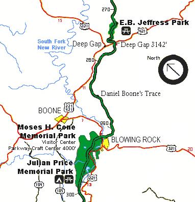
| 270.2 | Lewis Fork parking overlook, elev. 3290 |
| 271.8 | Right to E. B. Jeffress Park |
| 271.9 | |
| Cascades parking overlook, elev. 3570. Picnic area, self-guiding trail to Cascades pedestrian overlook (Falls Creek), trail to historic building. | |
| 272 | |
| E. B. Jeffress Park has a self-guiding trail to the Cascades and another trail goes to the old cabin and Cool Spring Baptist church. | |
| 272.5 | |
| Thompkins Knob parking area; trail to historic buildings | |
| 273.6 | Thompkins Knob, elev.3914 |
| 274.3 | Elk Mountain parking overlook, elev. 3789. E. |
| 274.5 | Joint crossing |
| 276.4 | Deep Gap, elev. 3142. U.S. 421, right 12 mi. to Boone; left 26 mi. to N. Wilkesboro |
| 277.1 | Stoney Fork Valley parking overlook, elev. 3405 |
| 277.7 | Osborne Mountain View parking overlook, elev. 3500 |
| 278.1 | Carroll Gap parking overlook, elev. 3430 |
| 279.2 | Public road crossing |
| 280.1 | Public road; no access |
| 280.8 | Access to U.S. 421 & 221, right 4 mi. to Deep Gap, 7 mi. to Boone; picnic area adjacent to U.S. 421 |
| 281.75 | Grandview parking overlook, elev. 3240 |
| 285.1 | Daniel Boone's Wilderness Road. E. Boone's Trace, which Daniel Boone blazed to the west, crosses near here. |
| 285.55 | Bamboo, elev. 3262. Access road to Boone on right |
| 288.1 | Public road crossing |
| 288.55 | Cemetery |
| 288.8 | Public road |
| 289.1 | Yadkin Valley parking overlook, elev. 3830 |
| 289.6 | Raven Rocks parking overlook |
| 290.5 | Thunder Hill parking overlook, elev. 3776 |
| 290.7 | Cemetery |
| 290.75 | Public road (Green Hill Road) |
| 291.9 | U.S. 321 & 221, right 7 mi. to Boone; left 2 mi. to Blowing Rock |
| 292.7 to 295 | |
| Moses H. Cone Memorial Park has 25 miles of Carriage Roads, ideal for hiking and horseback riding. Flat Top Manor houses the Parkway Craft Center. Fishing is available. | |
| 293.5 | |
| Moses Cone parking overlook, elev. 3865 294.0 Moses Cone Memorial Park Craft Center. Southern Highland Handicraft Guild handicraft shop, visitor center, and self-guiding trail; Cone family cemetery. S. | |
| 294.6 | Sandy Flat Gap. U.S. 221, eft 2 mi. to Blowing Rock, 13 mi . to Beacon Heights; right to Shulls Mills Road, Flannery Fork Road, and Trout Lake |
| 295.0 | Leave Cone Memorial Park, enter Julian Price Memorial Park |
| 295.1 to 298 | |
| Julian Price Memorial Park, the former retreat of an insurance executive, offers a variety of short trails and a lake. | |
| 295.4 | Sims Creek Viaduct, 85 ft. high, 385 ft. span |
| 295.9 | Sims Pond parking overlook, elev. 3447 |
| 296.5 | |
| Picnic area, 100 sites, 2 comfort stations | |
| 296.7 | Price Lake parking overlook, elev. 3393 S. |
| 297.15 | |
| Right to Campground; 99 tent sites, 62 trailer sites, 5 comfort stations | |
| 297.2 | |
| Parking overlook, elev. 3410. Amphitheatre and boat launching ramp. Left to Campground; 29 tent sites; 6 trailer sites, 1 comfort station. |
| Mile Post | |
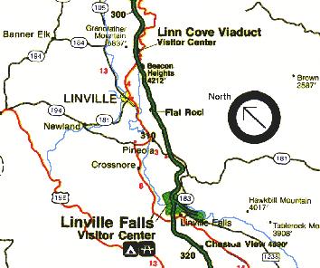
| 304.4 | |
| Linn Cove Viaduct, a design and engineering marvel, skirts the side of Grandfather Mountain. There is a visitor center and trails. The viaduct was the last section of the Parkway to be completed - 52 years after construction began. It is said to be the most complicated, concrete bridge ever built and the effort to build it was put forth in order to help preserve Grandfather Mountain. | |
| 305.1 | U.S. 221, Beacon Heights. Right 3 mi. to Linville. Nearby: Grandfather Mountain is a unique, privately owned wildlife and nature preserve. It is an ancient and most impressive mountain. There is an admission charge and permits are required to hike Grandfather Mountain trails. Linville Caverns is 4 miles south. |
| 305.25 | |
| Beacon Heights parking area, elev. 4212. A trail leads to good views of the east, south and west. | |
| 306.2 | Grandmother Mountain Gap, elev. 4051 |
| 306.6 | Grandfather Mountain parking overlook, elev. 4154 |
| 307.4 | Grandmother Mountain parking area, elev. 4063 |
| 307.6 | Parking widening, elev. 4015 |
| 307.9 | Public road, right 2 mi. to Linville; left to Roseboro |
| 308.3 | |
| Flat Rock parking area, elev. 3987. Self-guiding trail. Flat Rock is worth the walk for the superb view of Grandfather Mountain and Linville Valley. | |
| 310.0 | Lost Cove Cliffs parking overlook, elev. 3812. E. This is the best Parkway overlook for seeing the Brown Mtn. Lights - mysterious lights on the mountain that have no known logical explanation. |
| 312.25 | NC. 181, right 2 mi. to Pineola; left 32 mi. to Morganton |
| 315.6 | Camp Creek parking overlook, elev. 3442 |
| Mile 316.3 | |
| Linville Falls roars through a dramatic, rugged gorge. Trails to overlooks. Also check out NCNatural's Guide to the Linville Gorge, which offers much more detailed information on the area, including a photo gallery. | |
| 316.4 | |
| Linville Falls Campground, 55 campsites, 20 trailer sites, campfire circle, parking area, and self-guiding trails to Linville Falls overlooks | |
| 316.5 | |
| Linville River Picnic area, elev. 3250. 100 sites, 3 comfort stations. | |
| 316.6 | Linville River Bridge, elev. 3257 |
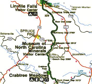
| 317.55 | U.S. 221, right 6 mi. to Spruce Pine; left to Linville Falls community, 24 mi. to Marion |
| 318.4 | North Toe Valley parking overlook, elev. 3540. S. |
| 319.8 | Humpback Mountain Viaduct |
| 320.7 | |
| Chestoa
View Trail provides spectacular views of vertical cliffs. |
| Mile Post | |
| 320.8 | Chestoa View parking area, elev. 4090'. Nice view of Table Rock Mountain. |
| 323.1 | Bear Den parking overlook, elev. 3359'. |
| 325.9 | Heffner Gap parking overlook, elev. 3067'. |
| 327.3 | North Cove parking overlook, elev. 2815 |
| 327.5 | McKinney Gap, elev. 2790. Public crossing, right S mi. to Spruce Pine; left 10 mi. to U.S. 221 |
| 328.6 | Apple Orchard parking overlook, elev. 2980.5. |
| 329.4 | Swafford Gap, elev. 2852 |
| 329.7 | Table Rock parking overlook, elev. 2870. E. |
| 330.9 | |
| Gillespie Gap, elev. 2819. N.C. 226, right to Visitor center at Museum of North Carolina Minerals. The Museum of North Carolina Minerals interprets the state's mineral wealth. Spruce Pine, 6 mi.; Marion, 14 mi.; N.C. 226A, Little Switzerland, 3 mi. | |
| 332.6 | Lynn Gap, elev. 3109 |
| 333.4 | Little Switzerland Tunnel, 547 ft. long |
| 333.9 | McCall Gap public road,elev. 3490. Left to Little Switzerland |
| 335.4 | Bearwallow Gap and Crabtree public road (no access), elev. 3482 |
| 336.3 | Gooch Gap, elev. 3360. Wildacres public road |
| 336.8 | Wildacres Tunnel, 249 ft.long |
| 337.2 | Deer Lick Gap parking overlook, elev. 3452. E. |
| 338.8 | Three Knobs parking overlook, elev. 3880 |
| Mile 339.5 | |
| Crabtree
Meadows turn pink in May. You can walk to Crabtree Falls and campgrounds
are available. Restaurant, gift shop, service station, campground, 71 campsites,
22 trailer sites, 3 comfort stations, amphitheatre. |
| Mile Post | |
| 340.5 | |
| Crabtree Meadows Picnic area, 82 sites, 1 comfort station | |
| 342.25 | Black Mountains parking overlook, elev. 3892. E. |
| 344.1 | |
| Buck Creek Gap parking overlook, elev. 3373. N.C.80, right 14 mi. to Micaville; left 6 mi. to Marion.S. Woods Mountain Trail. | |
| 344.56 | Twin Tunnel, 240 ft. long |
| 344.7 | Twin Tunnel, 401 ft. long |
| 345.3 | Singecat Ridge parking overlook, elev. 3406 |
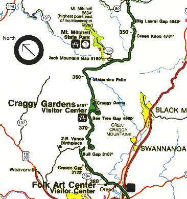
| 347.6 | Big Laurel Gap and U.S.F.S. road, elev. 4048 |
| 348.8 | Curtis Valley parking overlook, elev. 4460 |
| 349.0 | Rough Ridge Tunnel, 245ft. long |
| 349.2 | Licklog Ridge parking overlook, elev. 4602 |
| 349.9 | Mount Mitchell parking overlook, elev. 4821. E. |
| 350.4 | |
| Green Knob parking overlook, elev. 4761. Lost Cove Ridge Trail. | |
| 351.9 | |
| Deep Gap, elev. 4284. U.S.F.S. road right (gated). Deep Gap Trail. | |
| 352.6 | Big Pine Bear Stand, elev. 4479 |
| 353.9 | Cherry Log Ridge, elev. 4925 |
| 354.8 | Toe River Gap, elev. 5168. U.S.F.S. road (Old Perely Toll Road) left. |
| 355.0 | |
| Game warden's cabin, right. Bald Knob Ridge Trail. | |
| 355.3 | Black Mountain Gap, elev. 5160. Ridge Junction parking overlook, elev. 5160. Take NC. 128, west 4.8 mi. to Mount Mitchell State Park; NPS and commercial radio antennas. Mount Mitchell State Park has a picnic area and restaurant, lookout tower, and the highest point east of the Mississippi River. For more in-depth infromation about the Mt. Mitchell area and its history, be sure to visit our feature, "Elisha Mitchell and the Black Mountains" |
| 355.4 | Enter Asheville watershed |
| 358.5 | Highest point on Parkway north of Asheville, elev. 5676.5 |
| 359.8 | |
| Balsam Gap parking overlook, elev. 5320. Big Butt Trail. | |
| 361.1 | Cotton Tree Gap, elev. 5141 |
| 361.2 | Glassmine Falls parking overlook, elev. 5197. S. |
| 363.4 | Bullhead Gap. Graybeard Mountain parking overlook, elev. 5592 |
| 363.4 to 369.6 | Craggy Gardens seem covered with purple rhododendron in mid-June. Excellent wildflower viewing throughout the summer and into fall. |
| 364.1 | |
| Craggy Dome parking overlook, elev. 5640. Craggy Pinnacle Trail. | |
| 364.35 | Craggy Pinnacle Tunnel,176 ft. long |
| 364.4 | |
| Craggy Gardens visitor center, elev. 5497'. Self-guiding trail. Excellent views from a sharp ridge top. | |
| 365.5 | Craggy Flats Tunnel, 335ft. long |
| 367.6 | |
| Bee Tree Gap, elev. 4900'. Spur road right 1.38 mi. to Bear Pen (Craggy Gardens) picnic area, elev. 5220'. | |
| 368.2 | Potato Field Gap, elev.4600' (south end Asheville watershed). |
| 372.1 | Lane Pinnacle parking overlook, elev. 3890 |
| 373.8 | Bull Creek Valley parking overlook, elev. 3483. S. |
| 374.4 | |
| Tanbark Ridge Tunnel, 746 ft. long. Rattlesnake Lodge Trail is at the southside of the tunnel. | |
| 375.3 | Bull Gap, elev. 3107 |
| 375.7 | N.C. 694 (Elk Mountain scenic road), right 8 mi. to Weaverville |
| 376.7 | Tanbark Ridge parking overlook, elev. 2782 |
| 377.4 | Craven Gap, elev. 3132. N.C. 694 (Town Mountain Road) right 7 mi. to Asheville |
| Mile Post | |
| Mile 382 | |
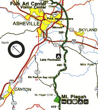
| The Folk Art Centeroffers sales and exhibits of traditional and contemporary crafts of the Appalachian Region. Interpretive programs are offered in addition to a gallery and library. Mountains To The Sea Trail and Shut-In Trail. | |
| 382.6 | U.S. 70, right 5 mi. to Oteen and Asheville; left 9 mi. to Black Mountain. Food and lodging available nearby in either direction. |
| 383.5 | Swannanoa River, elev.2040 |
| 384.7 | U.S. 74, right 5 mi. to Asheville; left 17 mi. to Bat Cave |
| 386.9 | Biltmore Estate reservoir |
| 388.85 | U.S. 25, right 5 mi. to Asheville; left 16 mi. to Hendersonville. Nearby; Biltmore House, estate of George Vanderbilt. Downtown Asheville. Blue Ridge Parkway Headquarters, 400 BB&T Building, One Pack Square, Asheville, NC 28801. Info (828) 298-5998 |
| 393.5 | French Broad River, elev. 2000'. |
| 393.6 | N.C. 191 & 280, right 9 mi. to Asheville. Nearby; North Carolina Arboretum. Gardens and Trails. 828-665-2492. Go North on 191 about 1/4 mile. Follow signs. |
| 393.8 | French Broad parking overlook, elev. 2100. S. |
| 395.1 | Glenn Gap, elev. 2495 |
| 396.4 | Walnut Cove parking overlook, elev. 2915 |
| 396.8 | Reynolds Gap, elev. 2865 |
| 397.1 | Grassy Knob Tunnel, 600ft. long |
| 397.3 | Sleepy Gap parking overlook, elev. 3920 |
| 398.3 | Chestnut Grove parking overlook, elev. 3035. E. |
| 399.3 | Pine Mountain Tunnel,1320 ft. long |
| 399.7 | Bad Fork Valley parking overlook, elev. 3350 |
| 400.3 | Bent Creek Gap, elev. 3270. U.S.F.S. road (gated) |
| 400.9 | Ferrin Knob Tunnel No.1, Trace Ridge, 360 ft. long |
| 401.1 | Wash Creek Valley parking overlook |
| 401.3 | Ferrin Knob Tunnel No.2, 310 ft. long |
| 401.5 | Ferrin Knob Tunnel No.3, 230 ft. long |
| 401.7 | Beaver Dam Gap parking overlook, elev. 3570 |
| 402.6 | Stony Bald parking overlook, elev. 3750 |
| 403.0 | Young Pisgah Ridge Tunnel, 400 ft. long |
| 403.6 | Big Ridge parking overlook, elev. 3815 |
| 403.9 | Fort Mountain Tunnel, 350 ft. long |
| 404.2 | Standhill Mountain parking overlook, elev. 3975 |
| 404.5 | Mills Valley parking overlook, elev. 4085 |
| 405.5 | Elk Pasture Gap (formerly Cutthroat Gap), elev. 4235 |
| 406.9 | Little Pisgah Tunnel, 500 ft. long |
| 407.4 | Buck Springs Tunnel, 380 ft. long |
| 407.6 | |
| Mount Pisgah parking area. Mt. Pisgah Trail and Buck Springs Trail. Mount Pisgah was part of the Biltmore Estate. The estate became home of the first U.S. forestry school and the nucleus of the Pisgah National Forest. For much more in-depth information on things to see and do in this area of the Pisgah National Forest, also visit our Pisgah Forest section. | |
| 407.7 | Buck Springs Gap parking overlook, elev. 4980 |
| 407.8 | |
| Mount Pisgah Picnic Area, 50 sites | |
| 408.4 | Flat Laurel Gap, elev. 4925'. |
| 408.6 | |
| Mount
Pisgah Inn, 29 units, restaurant, service station. Good food and views.
PO Drawer 749, Waynesville, NC 28786. 828-235-8228. |
|
| 408.8 | |
| Mount Pisgah Campground,73 tent sites, 75 trailer sites. Frying Pan Mountain Trail. | |
| 409.3 | Tunnel Top parking overlook, elev. 4925 |
| 409.6 | Frying Pan Gap, elev. 4931. |
| Mile Post | |
| 410.1 | Frying Pan Tunnel, 275 ft. long |
| 410.3 | The Pink Beds parking overlook, elev. 4825 |
| 411.0 | Rich Mountain parking overlook, elev. 4710 |
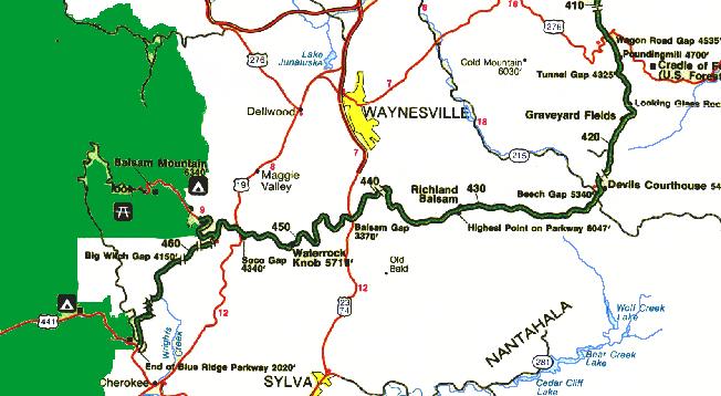
| 411.85 | Cold Mountain parking overlook, elev. 4542 |
| 411.9 | U.S. 276, right 22 mi. to Waynesville; left 17 mi. to Brevard. Nearby: towards Brevard to Cradle of Forestry, Sliding Rock, Looking Glass Rock, Looking Glass Falls and Pisgah Center for Wildlife Education. |
| 412.2 | Wagon Road Gap parking overlook, elev. 4550 |
| 412.5 | Pigeon Gap, elev. 4520 |
| 413.2 | Pounding Mill parking overlook, elev. 4700 |
| 414.2 | Bennett Gap, elev. 4402 |
| 414.9 | Bennett Cove, elev. 4525 |
| 415.6 | Tunnel Gap, elev. 4325 |
| 415.7 | Cherry Cove parking overlook, elev. 4330. E. |
| 416.3 | Log Hollow parking overlook, elev. 4445 |
| 416.8 | Bridges Camp Gap, elev. 4450 |
| 417.05 | |
| Looking Glass Rock parking overlook, elev. 4493. S. East Fork Trail. | |
| 417.8 | Seniard Gap, elev. 4775 |
| 417.9 | Yellowstone Falls |
| 418.3 | East Fork parking overlook, elev. 4955 |
| 418.8 | |
| Graveyard Fields parking overlook, elev. 5115. S. Graveyard Fields Loop Trail. | |
| 419.4 | John Rock parking overlook, elev. 5330 |
| 420.2 | Balsam Spring Gap, elev. 5550. U.S.F.S. road (gated) right. Access to Black Balsam area of Pisgah NF and Shining Rock Wilderness. |
| 421.1 | Old Silver Mine |
| 421.7 | Andromeda parking overlook |
| 422.1 | Devils Courthouse Tunnel, 650 ft. long |
| 422.4 | |
| Devil's Courthouse parking overlook, elev. 5462. Trail. S. Devil's Courthouse is a rugged exposed mountain top rich in Cherokee legends. A walk to the bare rock summit yields a spectacular view of Pisgah National Forest. | |
| 422.8 | Mount Hardy parking overlook, elev. 5415 |
| 423.2 | Beech Gap, elev. 5340. Right 23 mi. to Waynesville; left 17 mi. to Rosman |
| 423.5 | Courthouse Valley parking overlook, elev. 5362 |
| 423.7 | Tanassee Bald |
| 424.0 | Herrin Knob parking widening, elev. 5510 |
| 424.2 | Black Mountain Gap, elev. 5490 |
| 424.4 | Herrin Knob parking widening, elev. 5510 |
| 424.8 | Wolf Mountain parking overlook, elev. 5500 |
| 425.3 | Wolf Bald |
| 425.4 | Rough Butt Bald parking overlook, elev. 5300 |
| 425.5 | Buckeye Gap, elev. 5377 |
| 426.5 | Haywood Gap |
| 427.1 | Rough Butt Bald |
| 427.6 | |
| Bear Pen Gap parking area, elev. 5560. Bear Pen Gap Trail gives access to Mountains To The Sea Trail. | |
| 427.8 | Spot Gap parking overlook, elev. 5610 |
| 428.0 | Caney Fork parking overlook, elev. 5650 |
| 428.3 | Little Bear Pen Gap, elev. 5600 |
| 428.5 | Beartrap Gap parking overlook, elev. 5580. E. |
| 429.1 | Reinhart Gap, elev. 5455 |
| 430.0 | Reinhart Knob |
| 430.4 | Beartrail Ridge parking area, elev. 5865 |
| 430.7 | Cowee Mountain parking overlook, elev. 5960 |
| 431.0 | |
| Haywood-Jackson parking overlook, elev. 6020. Selfguiding trail. Richland Balsam's self-guiding trail takes you through a remnant spruce-fir forest. | |
| 431.4 | Richland Balsam parking overlook, highest point on Parkway, elev. 6050 |
| 432.7 | Lone Bald parking overlook, elev. 5635. Enter Waynesville watershed |
| 433.0 | Lone Bald |
| 433.3 | Locust Gap parking overlook, elev. 5580 |
| 433.4 | Locust Gap, elev. 5575 |
| 434.2 | Old Bald |
| 434.8 | Racking Horse Gap, elev. 5400 |
| 435.3 | Doubletop Mountain parking overlook, elev. 5365 |
| 435.7 | Licklog Gap parking overlook, elev. 5135 |
| 436.7 | Deep Gap, elev. 5260 |
| 438.8 | Brassy Ridge Mine parking overlook, elev. 5250 |
| 439.0 | Steestachee Bald parking overlook, elev. 4780 |
| 439.1 | Cove Ridge |
| 439.2 | Leave Waynesville watershed |
| 439.4 | Cove Field Ridge parking overlook, elev. 4620 |
| 439.7 | Pinnacle Ridge Tunnel, 750 ft. long |
| 440.1 | Saunook parking overlook, elev. 4375 |
| 440.9 | Waynesville parking overlook, elev. 4110 |
| 441.4 | Standing Rock parking overlook, elev. 3915 |
| 441.9 | Rabb Knob parking overlook, elev. 3725. S. |
| 442.2 | Balsam Gap parking overlook, elev. 3630 |
| 443.1 | Balsam Gap, elev. 3370. U.S. 19A & 23, right 8 mi.to Waynesville; left 12 mi. to Sylva |
| 444.6 | The Orchards parking overlook, elev. 3810 |
| 445.2 | Jones Knob parking overlook, elev. 4000 |
| 446.0 | Woodfin Valley parking overlook, elev. 4325 |
| 446.7 | Woodfin Cascades parking overlook, elev. 4535 |
| 448.1 | Wesner Bald parking overlook, elev. 4912 |
| 448.5 | Scott Creek parking overlook, elev. 5050 |
| 449.0 | Fork Ridge parking overlook, elev. 5280 |
| 450.0 | Yellow Face parking overlook, elev. 5610 |
| 451.2 | |
| Waterrock Knob parking overlook, elev. 5718. E. Waterrock Knob provides a panorama of the Great Smokies and 4 states. A trail, exhibits, and a comfort station are available. | |
| 452.1 | Cranberry Ridge parking overlook, elev. 5475 |
| 452.3 | Wollyback parking overlook, elev. 5420 |
| 453.4 | Hombuckle Valley parking overlook, elev. 5105 |
| 454.4 | Thunderstruck Ridge parking overlook, elev. 4780 |
| 455.1 | Soco Gap parking overlook, elev. 4570 |
| 455.4 | Overlook |
| 455.7 | Soco Gap, elev. 4340. U.S.19, right 8 mi. to Dellwood; left 12 mi. to Cherokee |
| 456.2 | Jonathan Creek parking overlook, elev. 4460'. |
| 457.6 | Docks Gap, elev. 4930'. |
| 457.8 | Plott Balsam overlook, elev.5020'. S. Named for the German immigrant who settled here in the early 19th century. |
| 457.9 | Cherokee Reservation Road; no access |
| 458.2 | Wolf Laurel Gap, elev.5100. S. Heintooga Ridge spur road goes to a mile-high overlook 1.3 miles from the parkway. |
| 458.8 | Lickstone Ridge Tunnel, 402 ft. long |
| 458.9 | Lickstone parking overlook, elev. 5150 |
| 459.3 | Bunches Bald Tunnel. 268ft. long |
| 459.5 | Bunches Bald parking overlook, elev. 4925. S. |
| 459.7 | Bunches Gap, elev. 4850 |
| 460.8 | Jenkins Ridge parking overlook, elev. 4445 |
| 461.2 | Big Witch Tunnel, 348 ft. long |
| 461.6 | Big Witch Gap, elev. 4160'. Bunches Creek Road to right, Cherokee Road (Wrights Creek) left |
| 461.9 | Big Witch parking overlook, elev. 4150'. E. The overlook views the home of the last important Cherokee medicine man, Big Witch, who was an 'eagle killer'. The eagle killers were responsible for gathering eagle feathers for use in ceremonies. |
| 462.35 | Barnett fire tower road |
| 463.9 | Thomas Divide parking overlook, elev. 3735 |
| 465.6 | Rattlesnake Mountain No.4 Tunnel, 410 ft. long |
| 466.25 | Sherill Cove No.6 Tunnel,572 ft. long |
| 466.7 | Sherill Cove parking overlook, elev. 2970 |
| 467.4 | Balihoot Scar parking overlook, elev. 2550 |
| 467.9 | Raven Fork parking overlook, elev. 2400 |
| 468.4 | Oconaluftee parking overlook, elev. 2200 |
| 469.1 | End of Blue Ridge Parkway. U.S. 441, right 29 mi. to Gatlinburg, Tenn.; left 2 mi.to Cherokee, N.C. Southern End of the Blue Ridge Parkway intersects with U.S. 441 in the Great Smoky Mountains National Park and the Cherokee Reservation. |
|
HEINTOGA SPUR |
|
| Mile Post | |
| 0.0 | Begin at Mile 458.2, Blue Ridge Parkway, Wolf Laurel Gap, elev. 5110 |
| 0.1 | Cherokee Reservation service road |
| 0.5 | Plott Ridge |
| 0.9 | Mollie Gap, elev. 5352. Cherokee Road (left) to Soco Bald |
| 1.3 | Mile High parking overlook, elev. 5250. S. |
| 1.4 | Maggie Valley parking overlook, elev. 5220 |
| 2.3 | Lake Junaluska parking overlook, elev. 4905 |
| 3.3 | Horsetrough Ridge parking widening |
| 3.4 | Horsetrough Ridge parking widening |
| 3.6 | Black Camp Gap parking area |
| 3.65 | Boundary, Great Smoky Mountains National Park |
| 3.9 | Parking overlook |
| 6.2 | Parking overlook |
| 8.4 | Balsam Mountain campground, elev. 5340. 47 sites, campfire circle |
| 8.9 | Heintooga Ridge picnic area, 37 sites |
| 9.0 | Parking
area; end of paved road. Fire road (one-way traffic in summer) continues to Round Bottom, Great Smoky Mountains National Park |
© 1995-2002 NCNatural,
Last updated
Park information , some pictures, and other stuff courtesy of Uncle Sam (
The BRP and the Park Service)