
& CAMPING
Blue Ridge Parkway Travel Guide
Virginia Mile by Mile Travelogue
Virginia Mile by Mile Travelogue
|
|
|
ABOUT US | | | CONTACT |
| HISTORY | | | HIKING & CAMPING |
| | TRAVELOGUE | | | DESTINATIONS | | | PHOTOS | | | LINKS | |||||||
|
Blue Ridge Parkway Travel Guide
Virginia Mile by Mile Travelogue
|
|||||||||||||||||
Points of Interest
Major points
of interest along the parkway are listed by milepost from the northern end in
Virginia to the southern end in North Carolina. Here are informational notes
pertaining to Virginia, indexed by section.
|
|
|
| Mile Post | |
| 0 | |
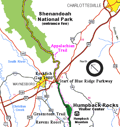
| Rockfish
Gap Near Waynesboro, Virginia, is the northern end of the Blue Ridge Parkway. To the north the parkway connects directly to Skyline Drive, which winds 105 miles through Shenandoah National Park. U.S. 250 and 1-64 take you to Charlottesville to the east and Staunton to the west. Rockfish Gap Tourist Information Center. |
|
| 0.2 | Afton overlook, elev. 1898 |
| 2.9 | Shenandoah Valley parking overlook, elev. 2354. E. |
| 4.4 | Va. 609, right to Sherando; left to Martin's store |
| 5 to 9.3 | |
| Humpback
Rocks. A humped appearance to the rocks gives the area its name. |
|
| 5.8 | |
| Humpback
Rocks Visitor Center Pioneer exhibit and demonstrations. Self-guiding Mountain Farm Trail through a reconstructed farmstead. |
|
| 6.1 | |
| Humpback Gap parking area, elev. 2360. S. A hiking trail from the parking area leads 0.75 mile to The Rocks. A section of the Appalachian Trail goes 2 miles to Humpback Mtn. | |
| 8.5 | |
| Humpback Rocks Picnic Area. 91 sites, 2 comfort stations. | |
| 8.8 | |
| Greenstone parking overlook, elev. 3007. Self-guiding Greenstone Trail. S. | |
| 9.2 | Laurel Springs Gap, elev.2878 |
| 9.6 | Dripping Rocks parking widening |
| 10.4 | Rockpoint parking overlook, elev. 3113. E. |
|
Map
- Mile 10+ to Mile 50+ |
|
| Mile Post | |
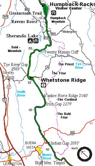
| 10.7 | Ravens
Roost offers vistas of Torry Mountain and the Shenandoah to the west. |
| 11.7 | Hickory Spring parking widening. Fountain. |
| 13.1 | Three Ridges parking overlook, elev. 2697 |
| 13.5 | Reeds
Gap, elev. 2637. Va. 664, right to Va. 814; left to Roseland and Amherst.
Nearby: Left on Va. 664 towards Wintergreen Ski Area and Resort. |
| 15.4 | Love Gap |
| 16.0 | Va. 814,
left to Massie's Mill. Elev. 1500'. Nearby: Sherando Lake is a recreation area in George Washington National Forest 4.5 miles from the parkway via Va. 814. Swimming, picnicking, and camping are available. |
| 17.6 | |
| The Priest parking overlook, elev. 2695. E. A short trail leads to a view. | |
| 18.5 | |
| White Rock Gap, elev. 2549. A 2.6 mile connecting trail leads to White Rock Falls Trail. | |
| 19.0 | Twenty-Minute Cliff parking overlook, elev. 2715. S. |
| 19.9 | |
| The Slacks parking overlook, elev. 2800. S. Trail to White Rock Falls, 0.9 miles. | |
| 22.1 | Bald Mountain parking widening, elev. 3250. U.S.F.S. road to Bald Mountain Tower |
| 23.0 | Fork Mountain parking overlook, elev. 3294 |
| 23.4 | Highest point north of the James River, elev. 3333.7 |
| 24.3 | Left, road to FAA Aircraft Direction Finder Station |
| 25.6 | Spy Run Gap, elev. 3033 |
| 26.4 | Parking overlook |
| 27.2 | Tye River Gap, elev. 2969'. Va. 56, right 4 mi. to Vesuvius, 6.5 mi. to Steeles Tavern; left .75 mi. to Montebello. |
| 29.0 | |
| Whetstone Ridge provided many a mountain man with a fine-grained sharpening stone.. Sandwich shop, gift shop, service station. Elev. 3000'. | |
| 29.5 | Va. 603; no access. Cemetery |
| 31.4 | Still-house Hollow parking widening. Fountain. |
| 31.9 | Va. 886; left, unimproved road to Montebello. |
| 33.0 | Yankee Fence exhibit. |
| 34.4 | |
| Yankee
Horse parking area, elev. 3140. Logging Railroad exhibit. S. Yankee Horse supposedly is where a hard-riding Union man's horse fell and had to be shot. See a reconstructed spur of an old logging railroad by walking to Wigwam Falls (0.2 miles). |
|
| 34.8 | Yankee Horse Ridge. |
| 37.4 | Irish Gap, elev. 2279 |
| 37.5 | Va. 605, right to Irish Creek and Buena Vista; left to Va. 60 and Amherst |
| 38.8 | Boston Knob parking area, elev. 2508. E. |
| 39.9 | Clark Mountain public road |
| 40.0 | Clarkes Gap, elev. 2177 |
| 42.4 | Irish Creek Valley parking widening, elev. 2665 |
| 44.4 | Whites Gap parking overlook, elev. 2567'. E. |
| 44.9 | Chimney Rock Mountain parking widening, elev.2485'. |
| 45.6 | Humphreys Gap, elev.2312'. Buena Vista overlook. U.S. 60, right 5 mi. to Buena Vista, 11 mi. to Lexington; left 23 mi. to Amherst. Nearby: lodging and campgrounds and services at Buena Vista. |
| 46.9 | Indian Gap. Public crossing; no access |
| 47.5 | |
| Indian
Gap Trail To Indian Rocks; good seasonal rhododendron display. 0.3 miles. |
|
| 48.9 | Licklog Springs Gap, elev.2481 |
| 49.3 | House Mountain parking overlook, elev. 2498 |
| 50.1 | Robinson Gap, elev. 2412 |
|
Map
- Mile 50 - Mile 80+ |
|
| Mile Post | |
| 50.5 | Va. 607; no access |
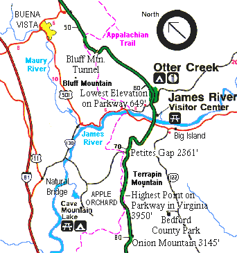
| 51.1 | U.S.F.S. road to Bluff Mountain Tower (gated) |
| 52.8 | Bluff Mountain parking overlook, elev. 1850. S. |
| 53.1 | Bluff Mountain Tunnel, 630 ft. long |
| 53.6 | Rice Mountain parking overlook, elev. 1755 |
| 54.1 | Browns Creek, elev. 1560 |
| 55.1 | White Oak Flats parking overlook, elev. 1460 |
| 55.2 | Otter Creek, elev. 1458 |
| 55.9 | Dancing Creek parking overlook, elev. 1300 |
| 57.6 | Upper Otter Creek overlook |
| 58 to 63.6 | Otter Creek runs 10 miles down the Blue Ridge to the James River. Otters don't play here anymore, but people do. |
| 58.2 | Otter Creek Flats parking overlook, elev. 1055 |
| 59.7 | Otter Creek parking overlook |
| 60.4 | The Riffles parking overlook, elev. 825 |
| 60.8 | |
| Otter Creek. Campground, 42 tent sites, 25 trailer sites, campfire circle, coffee shop, gift shop, service station. Otter Creek Trail. | |
| 61.4 | Terrapin Hill parking overlook, elev. 760 |
| 61.6 | Otter Creek Bridge. Va. 130, right 2 mi. to U.S. 501, 8 mi. to Glasgow; left 12 mi. to Elon, 20 mi. to Lynchburg. Nearby: Natural Bridge, via US 501. |
| 62.5 | Lower Otter Creek parking overlook, elev. 685 |
| 63.1 | |
| Otter Lake parking overlook, elev. 655. Fishing and hiking on Otter Lake Trail. | |
| 63.6 | |
| James River overlook. A self-guiding trail, footbridge and trail to Kanawha Canal lock exhibit. Trail of Trees Trail. | |
| 63.65 | Cemetery |
| 63.7 | James River Bridge. U.S. 501, right 9 mi. to Glasgow; left 2 mi. to Big Island, 22 mi. to Lynchburg. Lowest point on Parkway. Elev. 670'. |
| 63.8 | |
| James River Visitor Center. At the James River and Kanawha Canal a footbridge leads across the river to the restored canal locks and exhibits. A self-guiding trail goes along the river bluff. | |
| 67.1 | Falling Rock Creek |
| 68.6 | Trail to Marble Spring Lean-to (Appalachian Trail Conference) |
| 69.1 | James River Valley parking overlook, elev. 1874 |
| 71 | Petite's
Gap is named for a local family. elev. 2361 Nearby: The road to the west goes to Cave Mountain Lake, 7 miles away, in Jefferson National Forest. Swimming, picnicking, and camping are available. |
| 72.6 | Terrapin Mountain parking widening, elev. 2884. |
| 74.7 | Thunder Ridge parking area, elev. 3485'. Thunder Ridge Loop Trail. |
| 74.8 | Thunder Hill, elev. 3510 |
| 75.5 | Arnold Valley parking widening |
| 76.2 | U.S. Air Force road |
| 76.5 | Apple Orchard parking widening, elev. 3933.5'. Highest point on the Parkway in Virginia. Apple Orchard Mountain summit is 4229'. |
| 76.6 | U.S. Air Force access road to Bedford radar installation on Apple Orchard Mountain |
| 76.7 | Highest point on Parkway in Virginia, elev. 3950 |
| 78.4 | |
| U.S.F.S. Road 35. Right to Welch; left to Methodist Church camp. Sunset Field overlook. Apple Orchard Falls Trail. | |
| 79.7 | |
| Onion Mountain parking overlook, elev. 3145. Onion Mountain's short loop trail takes you through rhododendron and mountain laurel, which bloom in early June. | |
| 80.0 | Black Rock Hill parking widening |
|
Map
- Mile 80+ to Mile 110+ |
|
| Mile Post | |
| 80.0 | Black Rock Hill parking widening |
| 81.9 | Headforemost parking widening, elev. 2861. Fountain. E. |
| 83.4 | |
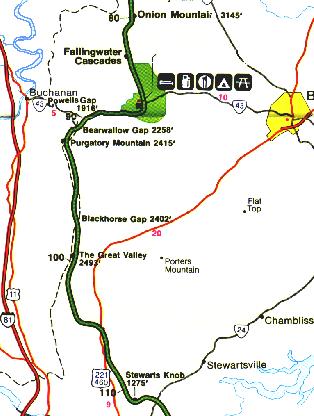
| Fallingwater Cascades can be seen along a 1.6-mile loop trail (begins at 83.1 mi.) | |
| 83.5 | Vilkinson Gap, elev. 2511. |
| 83.6 | |
| Flat Top Mountain Trail parking area, elev. 2610. Flat Top Trail and Cross Rock Trail. | |
| 84 to 87 | Peaks of Otter has been a popular location to see spectacular views and sunrises since the days of Thomas Jefferson. A shuttle bus provides passenger service to Sharp Top. |
| 85.5 | Polly Woods' Ordinary |
| 85.65 | |
| Peaks of Otter Concession Area, elev. 2525. Lodge (56 rooms), restaurant, grill, gift shop, 24-acre lake. Lodge open May-October. P.O. Box 489, Bedford, VA 24523. Info and reservations, call 540-586-1081. | |
| 85.7 | |
| Abbott Lake Trail Loop around Abbott Lake. |
|
| 85.89 | Cemetery |
| 85.9 | |
| Va. 43;Peaks
of Otter Visitor Center (right). Ranger office, service station, amphitheatre,
self-guiding Elk Run Trail, Hearkening
Hill Trail, Balance Rock Trail,
trail to Johnson Farm group. Peaks of Otter, elev. 2535' (left). Camp store; restrooms; bus station for trips up Sharp Top Mountain (elev. 3875'); trail to Sharp Top Mountain. Campground, 80 tent sites, 62 trailer sites; Little Stony picnic area, 62 sites.S. |
|
| 89.1 | Powell's Gap, elev. 1916 |
| 89.4 | Upper Goose Creek parking overlook, elev. 1925'. |
| 90.0 | Porters Mountain parking overlook, elev. 2102'. E. |
| 90.9 | Bearwallow Gap, elev. 2258'. Va. 695, left to U.S. 460. Va. 43, right 4 mi. to Buchanan |
| 91.8 | Mills Gap parking widening, elev. 2432'. |
| 91.9 | Mills Gap, elev. 2425 |
| 92.2 | Purgatory Mountain parking widening, elev. 2415 |
| 92.6 | Sharp Top parking widening, elev. 2415 |
| 93.1 | Bobblets Gap parking overlook, elev. 2418. Bobblet Cemetery |
| 93.2 | Bobblets Gap. Va. 617; no access |
| 94.1 | U.S.F.S. Hammond Trail |
| 95.2 | Pine Trees parking overlook, elev. 2490'. |
| 95.3 | Harveys Knob parking overlook, elev. 2524'. |
| 95.9 | Montvale parking overlook, elev. 2441'. |
| 96 | |
| Spec
Mine Trail USFS Trail begins near Montvale Overlook, to State Rt. 645 in Botetourt County. |
|
| 96.6 | Iron Mine Hollow parking widening, elev. 2365'. |
| 96.9 | Taylor Mountain parking overlook, elev. 2340'. |
| 97.6 | Black Horse Gap, elev.2402'. |
| 99.6 | Great Valley parking overlook, elev. 2493'. S. |
| 100.9 | The Quarry parking overlook, elev. 2170'. |
| 101.5 | Curry Gap, elev. 1985'. |
| 104.4 | Va. 652; no access |
| 104.8 | Va. 657; no access |
| 105.0 | U.S. 460 accommodation folder rack. Leaflets and bulletins. |
| 105.8 | U.S. 460, right 9 mi. to Roanoke; left 20 mi. to Bedford. |
| 107.5 | Va. 738; no access |
| 107.6 | GladeCreek |
| 107.7 | Va. 685; no access |
| 108.4 | Va. 604; no access |
| Mile Post | |
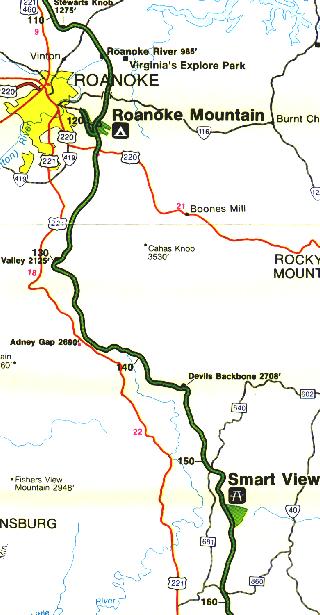
| 110.6 | Stewarts Knob parking overlook, elev. 1275. S. |
| 111.6 | Va. 651; no access |
| 112.2 | Va. 24, right 5 mi. to Roanoke; left 4 mi. to Stewartsville. Nearby: Smith Mountain Lake. |
| 113.6 | Va. 634; no access |
| 114.8 | Roanoke River Bridge, river elev. 825 |
| 114.9 | |
| Roanoke River Gorge opens before you from the overlook at the end of a 10-minute walk. | |
| 115.3 | Va. 618; no access |
| 116.2 | Dundee |
| 116.4 | Va. 658; no access |
| 117.2 | Va. 617; no access |
| 117.6 | Cemetery |
| 117.65 | Va. 116; no access |
| 118.6 | Va. 666; no access |
| 119.2 | Va. 668; no access |
| 119.8 | Yellow Mountain loop exit |
| 120.3 | Roanoke Mountainloop road is a 3.7-mile side trip. The one-way loop road takes you over the mountain for impressive views. There are steep grades and towed vehicles are prohibited. |
| 120.5 | |
| Mill Mountain Spur Rd. 1.3 miles to Roanoke Mountain Campground, 60 campsites, 40 trailer sites, campfire circle. Roanoke Mtn. Summit Trail and Chestnut Ridge Trail. | |
| 121.4 | |
| Roanoke
Valley Horse Trail Begins at U.S. Hwy 220 and parallels Parkway to Milepost 110.6. |
|
| 121.5 | U.S. 220, accommodation folder rack. Leaflets and bulletins. Right 5 mi. to Roanoke; left 21 mi. to Rocky Mount |
| 122.4 | Va. 679; no access |
| 123.2 | |
| Buck Mountain parking overlook, elev. 1465. Trail to summit (0.53 mi.) | |
| 124.15 | Va. 613; no access |
| 124.4 | Back Creek, elev. 1160 |
| 124.45 | Va. 615; no access |
| 126.1 | Va. 688; no access |
| 126.2 | Masons Knob parking overlook, elev. 1425 |
| 127.6 | Va. 691; no access |
| 128.7 | Metz Run parking overlook, elev. 1875 |
| 128.8 | Va. 690; no access |
| 129.3 | Poages Mill parking overlook, elev. 2032 |
| 129.6 | Roanoke Valley parking overlook, elev. 2125'. E. Roanoke Overlook provides a panoramic view of the largest community along the parkway. The city can be reached via U.S. 220 (at 121), Va. 24 (at 112), and U.S. 460 (at 105). |
| 129.7 | Viaduct |
| 129.9 | Lost Mountain parking overlook |
| 131.0 | Va. 690; no access |
| 132.0 | Dividing Springs, elev. 2800 |
| 133.0 | Slings Gap parking overlook, elev. 2860'. |
| 133.1 | Slings Gap, elev. 2825. Va. 612; no access |
| 133.6 | Bull Run Knob parking overlook, elev. 2890'. |
| 134.3 | Lancaster Gap, elev. 2786'. |
| 135.6 | Cemetery |
| 135.9 | U.S. 221, right 19 mi. to Roanoke. |
| 136.0 | Adney Gap, elev. 2690'. Va. 602; no access |
| 136.1 | Cemeteries. Access to Va. 602 |
| 138.5 | Sweet Annie Hollow, elev.2889. Va. 648; no access |
| 139.0 | Cahas Knob parking overlook, elev. 3015 |
| 141.0 | Cemetery |
| 142.2 | Cemetery |
| 142.9 | Cemetery |
| 143.5 | Cemetery |
| 143.95 | Devils Backbone parking overlook, elev. 2708'. E. View. |
| 144.3 | Pine Spur Gap |
| 144.8 | Pine Spur parking overlook, elev. 2703'. Named for the white pines in the area. |
| 144.9 | Pine Spur recreational area |
| 145.7 | Va. 791 |
| 146.4 | Va.642 |
| 146.5 | Bell Spring House |
| 148.15 | Va.641 |
| 148.4 | Va.663 |
| 149.1 | Va.640 |
| 150.5 | Va. 639. Payne Creek Church |
| 150.8 | Kelly Spring House. Right to Va. 681; left to Va. 640 (Franklin Turnpike) |
| 152.0 | Va.668 |
| 153.2 | Va.888 |
| 153.5 | Va.888 |
| 154.1 | Smart View parking overlook, elev. 2564 |
| 154.5 | |
| Smart View picnic area. 42 sites, 2 comfort stations, historic building (Trail's Cabin). S. Smart View is just that; go to the Trail Cabin built in the 1890s and you'll see "a right smart view," especially in early May when the dogwoods bloom. | |
| 155.3 | Va. 793, left 4 mi. to Endicott; right connects with Va. 680 |
| 156.5 | Va. 635 |
| 157.6 | Shorts Knob parking overlook, elev. 2806 |
| 158.9 | Va. 637, right to Floyd |
| 159.3 | Va. 860, right to Floyd; left to Endicott and Ferrum |
| Mile Post | |
| 160.9 | Va. 615, right to Floyd |
| 161.2 | Va.708 |
| 162.1 | Va.714 |
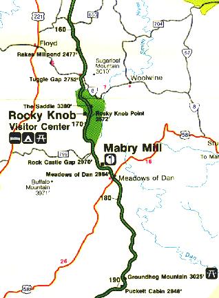
| 162.4 | Rakes Mill Pond parking overlook, elev. 2477. S. |
| 162.7 | Big Poplar Tree |
| 162.9 | Va.710 |
| 163.2 | Va. 797. Thomas Grove Baptist Church |
| 163.5 | Va. 709 |
| 165 | Flame Azaleas set the plateau ablaze in tones from yellow to deep red in mid-May. |
| 165.3 | Tuggle Gap, elev. 2752 |
| 165.35 | Va. 8,
right 6 mi. to Floyd; left 21 mi. to Stuart. Nearby: Fairy Stone State Park is known for unusual cross-shaped crystals found in the area. VA 8, east to VA 704 east. |
| 167 to 174 | Rocky Knob rises like the cresting of a wave to overlook Rock Castle Gorge. |
| 167.1 | |
| Rocky Knob. Elev. 3572'. Right to Campground, 82 tent sites, 28 trailer sites, campfire circle, Rock Castle Gorge Trail, Hardwood Cove Nature Trail.; Left to Rocky Knob trail. | |
| 168.0 | Saddle parking overlook,elev. 3880'. Self-guiding trail. S. |
| 168.2 | Rocky Knob |
| 168.7 | Rock Castle Gorge parking overlook, elev. 3195 |
| 169.0 | |
| Rocky Knob Visitor Center. Picnic Area - 72 sites, 4 comfort stations, gas station. Black Ridge Trail, Rocky Knob Picnic Loop Trail. | |
| 169.2 | Pump House road |
| 170.4 | Va.720 |
| 171.3 | Va.720 |
| 171.6 | Cemetery. S. |
| 171.7 | Va.726 |
| 172.7 | Belcher Curve |
| 174.0 | Rock Castle Gap, elev. 2970. Va. 799, right to Willis, Hubbards Mill |
| 174.1 | |
| Left to Rocky Knob Cabins. 8 housekeeping cabins, open May 30 - Labor Day. Rt. 1 Box 5, Meadows of Dan, VA 24120. Phone 540-593-3503. | |
| 174.2 | Va. C-758, right to Buffalo Mountain state fire lookout |
| 174.25 | Va. 778 |
| 174.3 | Laurel Creek |
| 174.7 | Va. 778 |
| 175.1 | Va.778 |
| 175.8 | Cemetery |
| 175.9 | Va. 603, Rocky Knob cabins |
| 176.1 / 176.2 | |
| Mabry Mill, elev. 2855'. Information, coffee shop, gift shop, water-powered sawmill, carpenter shop, and working grist mill. Self-guiding pioneer industry trail, including blacksmith and wheelwright shop exhibit, mint still, whiskey still, Matthews Cabin. Molasses and apple butter-making exhibit in season. Mabry Mill was operated by E.B. Mabry from 1910 to 1935. A trail takes you to his gristmill, sawmill, blacksmith shop, and to other outdoor exhibits. Old-time skills are demonstrated in the summer and fall. | |
| 177.7 | Meadows of Dan, elev.2960'. U.S. 58, right 21 mi. to Hillsville; left 16 mi. to Stuart. Nearby; Virginia Museum of Natural History, US 58 Bus. at Rt. 220. Free. 540-666-8600. |
| 178.3 | Cemetery |
| 178.8 | Va.744 |
| 179.3 | |
| Round Meadow parking overlook. Round Meadow Creek Loop Trail - 1/2 mile walk through a stream bottom forest.Trail | |
| 179.4 | Round Meadow Viaduct, elev. 2800. Round Meadow Creek, elev. 2690 |
| 180.1 | Mayberry Presbyterian Church and Cemetery. Va. 600 |
| 180.5 | Va. 634, Yeatts store contiguous on right |
| 180.6 | Mabry Gap |
| 180.7 | Mayberry Creek, elev. 2775 |
| 181.4 | Cemetery. Access to Va.602 left |
| 183.4 | Pinnacles of Dan, elev.2875 |
| 183.9 | Access to Va. C-614 |
| 184.2 | Cemetery. Access to old Va. 614 |
| 185.0 | Va. C-638; no access |
| 186.4 | Cemetery and parking area at private road crossing. Access to Va.C-608 |
| 186.7 | Va. C-63 1, right to Laurel Fork |
| 187.7 | Va. 639 |
| 188.8 | |
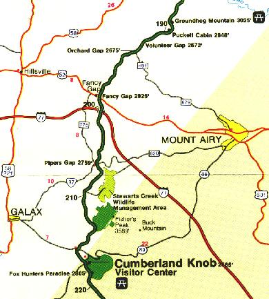
| Groundhog Mountain parking overlook, elev.3025. Picnic area, 26 sites and 1 comfort station, trail from parking area to observation tower, cemetery in parking area island. S. Groundhog Mountain is a good place to see different kinds of country fences--snake, post and rail, picket, and buck. There are picnic grounds and an observation tower. | |
| 188.9 | Va. 608; Va. C-608, no access |
| 189.1 | Pilot Mountain parking overlook, elev. 2950 |
| 189.9 | Puckett Cabin parking area, elev. 2848'. Historic building. S. Home of local midwife Orelina Hawks Puckett. |
| Mile Post | |
| 190.6 | Va. 608 |
| 191.4 | Va.608 |
| 191.9 | Bluemont Presbyterian Church and Cemetery at private road crossing |
| 192.3 | Va. C-648, left to Mt. Airy; left on Va. C-771 to Wilus Gap |
| 193.2 | Volunteer Gap, elev. 2706 |
| 193.7 | Orchard Gap, elev. 2675. Va. 691, right to Hillsville; left to Mt. Airy |
| 194.7 | Va. 608 |
| 195.5 | Wards Gap, elev. 2750. Va.608; no access |
| 196.45 | Va. 682 |
| 198.4 | Va. 685, left to Va. C-608 |
| 199.0 | Va. 608 |
| 199.1 | Turnoff connects with U.S. 52 |
| 199.4 | Fancy Gap, elev. 2925. U.S.52, left 14 mi. south to Mt. Airy. 1.5 miles north to I-77. |
| 199.9 | Va. C-778 |
| 202.25 | Va.608 |
| 202.8 | Granite Quarry parking overlook, elev. 3015. S. |
| 203.9 | Piedmont overlook |
| 204.85 | Va. 700 |
| 205.75 | Va. 608 |
| 206.1 | Piper Gap, elev. 2759. Va. 620; no access |
| 206.35 | Va. 608, right to Va. 620 and 97 |
| 206.9 | Mt. Carroll Methodist Church and Cemetery |
| 207.75 | Va. 608 |
| 208.25 | Blue Ridge Church and Cemetery; access to Va.C-608 |
| 209.35 | Va. 715, right to Galax |
| 209.85 | Va.716 |
| 209.9 | Hank's Branch |
| 211.1 | Va.612 |
| 212.2 | Hank's Branch |
| 213.1 | E. Fork Chestnut Creek |
| 213.3 | Va. C-612 |
| 215.15 | W. Fork Chestnut Creek |
| 215.3 | Va.799 |
| 215.7 | W. Fork Chestnut Creek |
| 215.85 | Va. 89, right 7 mi. to Galax; left 22 mi. to Mt. Airy |
| 216.0 | W. Fork Chestnut Creek |
| 216.25 | W. Fork Chestnut Creek |
| 216.9 | State Line, Virginia and North Carolina |
| 217.3 | Road connects with N.C.18; right 15 mi. to Sparta; left 22 mi. to Mt. Airy |
| 217.5 | |
| Cumberland Knob, at 2,885' feet, is a delightful spot to walk through fields and woodlands. Cumberland Knob Trail and Bully Creek Trail. Visitor Center, parking, picnic area, 25 sites, comfort stations, shelter, cemetery. Elev. at Parkway 2740'. | |
| 218.6 | |
| Fox Hunters Paradise, a 10-minute walk, is where hunters could listen to their hounds baying in the valley below. Fox Hunters Paradise parking overlook, elev. 2805. Trail to High Piney Spur.S. |
© 1995-2002 NCNatural,
Last updated
Park information , some pictures, and other stuff courtesy of Uncle Sam (
The BRP and the Park Service)